Retired and on the Move

My Photo
Name:
Location: BC, Canada

Friday, March 23, 2007

Saint-Malo

17-18 March 2007

From Noirmoutier we headed north and inland past Rennes and on to historic Saint-Malo, the walled city on the English Channel from which Jacques Cartier sailed in 1565 to “discover” Canada. Depending on one’s definition of “Canada” and of “discover” this statement is more or less accurate if we assume that we are talking of Canada prior to Newfoundland’s joining Confederation in 1949 and provided that “discover” means discovery by the first Europeans to sight continental Canada. Even that might be questioned based on the possibility that the Norse or Icelanders landed somewhere on continental Canada in addition to their settlement at l’Anse aux Meadows in Newfoundland.

Historical debates aside, St.-Malo, the City of Corsairs (privateers) is an interesting site. The city’s name is derived from the Welsh monk Mac Low, who in the 6th century established his bishopric at Alet near the rock where the walled city now stands.

Following extensive damage during allied bombardments in 1944 during the Allied invasion of Europe, the walled city and its cathedral were subsequently rebuilt, in the same mould though not as precise replicas of the pre-war period. Some streets were straightened and widened and some buildings altered.

The tides here are quite dramatic. The extensive launch ramp even has a 90 degree corner leading to a second level.


The yachts in the foreground have entered a lock carrying them from the ocean to this basin where the water level is constant regardless of the tidal level beyond the locks.


There are 3 gates into the walled city.


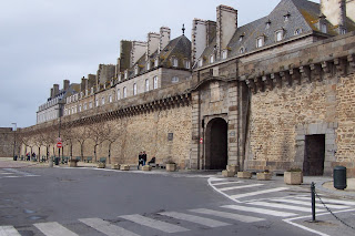
During the summer these streets are filled with tourists.


The Cathédrale de Saint-Vincent has its roots in the 4th century and some parts of an earlier monastery church are included in the structure. In the 12th and 13th centuries various parts of the Choir and Nave were expanded. In 1422 construction began on the tower of the transept but was only completed in the 18th century some 300 years later. Many other additions and alterations followed over the centuries. But as mentioned above, the Allied invasion of 1944 resulted in extensive damage and the post-war period saw another major rebuilding of the cathedral.


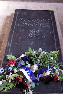
It is during this period that Jacques Cartier’s tomb was unearthed and relocated.


The cathedral floor boasts a memorial (created as a souvenir of the 1891 visit of the Prime Minister of Québec) of Jacques Cartier kneeling to receive the blessing of the bishop prior to his sailing for North America to “discover Canada” in 1535.


Politics aside Saint-Malo is an interesting historic site with its extensive fortifications both in the walled city and in the harbour.


While the 90 km/hour wind is not evident in the picture one big raindrop can be seen above the fort. With more of the same weather predicted for the next week, we decided to end our rambles around France, bypass Mont-Saint-Michel and Dunkerke and head straight for Belgium.


As it worked out our last day in France, the last day of winter, dawned in appropriate fashion. And we had been so smug about our winter without snow!!!

Ile de Noirmoutier

16-17 March 2007

Travelling by motor home really facilitates moving on with no set itinerary or even a destination. Looking at a map will often suggest an interesting place. Ile de Noirmoutier was one of those interesting looking places that really was interesting. In part we were attracted by its long narrow landmass reaching out into the Atlantic. And the map notation « Passage du Gois (route practicable à bas mer) » (usable route only at low tide) seemed intriguing.

Jutting about 20 km into the Atlantic and varying in width from 1 to 6 km, Nourmoutier, until 1971, was accessible only by boat or at low tide by the 4.15 km long “Gois”. The Gois is covered by asphalt or paving blocks. With a large tidal range, at high tide the Gois can be covered by as little as 1.3 meters and as much as 4 meters of water.

The pylons mark the route and serve as something of a last resort refuge for those caught by the tide. No doubt there have been a few water-logged engines since the tide comes in very quickly over a flat sea bottom. The Gois was built in 1766 and ultimately paved 170 years later between 1935 and 1939 (during low tides). For the faint-hearted, or those who miss the low tide window, the 583 meter long bridge provides a less challenging route to the Isle.

For once the tourist literature does not overstate the case for a visit. “It is like being in a dream. There are white walled houses on the seafront. Flowers everywhere. Beaches of fine golden sand fringed by pine forests, green oaks, woods and mimosa. Sand dunes. There are natural salt marshes, reserves where large numbers of wild birds fly freely. There are windmills, a castle, museums and old sailing rigs. There is music in the bars and in people’s hearts. Theatre, shows and crowds clapping; happy people. Busy markets, shopkeepers, craftsmen, flea markets and displays. Light and colour are everywhere. Painters, artists. And – there is a peacefulness and the sound of lapping waves. The sea draws back and creates, as if by magic, a passage, a road. The fresh wind gusts and the air feels good. Bicycles follow the lanes and paths. There is also the sea spray – boats, yachts, regattas and the ports are full of life. There are horses, playing fields and trails to meander along…” For us it was all of this, except the crowds. Ah we love that late winter in the south when there are no crowds, the breeze is light and the sun is warm. A good book, a jug of wine, … and thou.


The island’s church has a long history. Dedicated to Saint-Philbert, it arose on the site of an abbey created by Philbert in 677 AD. Pillaged by the Saracens at the beginning of the 8th century, it was rebuilt at the end of the 11th century (the nave and the choir) over the primitive chapel of Saint-Philbert, the actual crypt of today’s church.

Between the late 1500’s and the middle of the 17th century the nave was expanded on the left and right. It is situated across from the 12th century fortified château.

Despite its age, Saint Phibert’s has a sense of light and a feeling of lightness and airiness.


The magnificently preserved 12th century castle promised to “vous séduire par son architecture remarquable”. Since it was closed for major renovations to one of its towers, we had to be satisfied with being “virtually” seduced by its remarkable architecture since all we could see were the external walls.


As promised there were historic sailing ships, aground and propped up at low tide.


There was abundant evidence of farming, including the harvesting of sea salt by flooding these beds at high tides and then sealing them off to evaporate, leaving the sea salt behind. If you’ve been reading your bilingual containers in Canada you’ll know that “sel” is French for salt.


The promised restaurants were there. Here Marie-Claire enjoys a cheese, ham and egg “gallette” – a square crèpe - and her red wine while Roger works on a tasty, brown Pelforth to accompany his gallette.


And there are indeed white houses by the sea – in this case the small, traditional homes of fisherman in le Petit Vieill.


The happy crowds were not there although were happy people on the streets.


And there are indeed excellent bicycle paths joining all 6 communities on the Isle. And lots of quiet reserves for aquatic birds.

So whether you choose the modern bridge or the ancient low tide causeway to the Ile de Noirmoutier, drive, walk or cycle your way to this idyllic spot.

La Tranche-sur-Mer

14 March 2007

Our practice of following as many secondary roads (small départementals) as possible, led us to a small village, Marans. Attracted by the ruins of a church we stopped in a large parking lot where one large multi-wheeler truck was parked. The restaurant across the road should have been a hint. But we missed it. Within about 90 seconds, the restaurant owner, wrapped in his soiled apron came running across the road gesticulating expressively, as the French can do so well. Once we understood that he wanted to save as much of the parking lot for “les routiers” (truckers) to stop for lunch and recognizing the sanctity of lunch (and dinner) for les routiers we moved to the end of the lot. Sure enough there were soon 8 multi-wheelers. In a previous trip to France, to the east of Lyon, we had awaited a fixed menu dinner with about 20 routiers in the only restaurant open on a Sunday evening along a départemental. Being a routier in Europe is a tough job. The cabs are much smaller, with very small sleeping areas and no facilities. Once off the autoroutes, they are pushing their rigs along extremely narrow roads usually with no shoulders and the cab-over construction of their trucks means there is absolutely no protection in the event of a head-on collision. Like we said, it’s a tough job, so meals and the social aspects of meals are an important event in the day of a routier. Who are we to begrudge them a parking spot for their long rigs?

Lunch completed, we explored the ruins of this church dating to the Roman era for parts of its choir and transept, and to the middle ages for the rest.

Its massive, sophisticated stone and brick work have maintained much of the structural integrity of the church over its 100 years of abandonment.

The date of the wagon alongside the church is debatable – probably the end of the 19th or early 20th century. The springs and metalwork are suggestive of this era.


Following secondary, narrow roads brought us to the most picturesque “mairie” (town hall) of this year’s trip in Saint-Benoist-sur-Mer.


It’s a long time since this Saint-Benoist was on the sea, but it did have a beautiful but simple medieval church.


Although a very solid, boxy structure it still had a high level of natural interior light.


An overnight stop at la Tranche-sur-Mer provided a quiet night’s rest. Unfortunately “les floralies” area of la Tranche was no longer being cultivated and maintained by the town so some anticipated flowers in the dunes were not to be found. Some good cycling paths filled our time.

Gironde Estuary and Rochefort

13 March 2007

A ferry about 1½ times the size of the Horseshoe Bay to Bowen Island ferry crosses the mouth of the Gironde Estuary from Verdon to Royan. The Gironde is the largest estuary in Europe (at least western Europe), and covers 635,000 square km; is 75 km long and 11 km at its maximum width. A long geological history has produced the estuary in its broad modern outlines and led to 3000 years of various forms of navigation on and from the estuary: Viking longboats, Louis XIV’s privateers, Dutch traders, corvettes and frigates, self-propelled barges (péniches), bulk freighters and oil tankers. With shifting sand banks and islands, river pilots have long been a feature of estuary navigation.

The estuary was controlled by England at various times beginning in 1154 with the marriage of Henry Plantagenet to Aliénor d”Aquitaine. As part of the marriage dowry, Henry received the bordelaise lands. An earlier post (Hastingues 3 March 2007) covered some of this tempestuous relationship. The trade of the period was chiefly Bordeaux wines and by 1305, 100,000 barrels were being shipped to England. By the 18th century, Bordeaux had become the 2nd biggest slave trading city in France with 130,000 to 150,000 Africans being landed along the estuary. By the 1800’s Le Havre began to overtake Bordeaux as the major port; this trend was quickened with the advent of railways and the subsequent decline of river and estuary traffic. With Le Havre’s location right on the Atlantic it was well placed to take advantage of these changes in the technology of transportation.

A physical phenomena of the estuary is its “mud cork”. Alluvial particles carried from inland, mostly by the Garonne River (2 – 3 million tons a year) move to and fro in the water, eventually agglutinating to form the mud cork. This mass of particles can be up to 30 km long. When the river flow is strong the floating mass of mud cork moves down the estuary; when the flow is slow it can move up the Garrone river past Bordeaux to La Réole (about 110 km from the ocean; when the flow is very weak the mass can sink to the bottom; in the spring with higher tides and the strongest river flow the mud cork, if it is in the middle of the estuary, will be pushed out of the estuary mouth into the ocean.

When we crossed from Verdon to Royan in the closing weeks of winter, we didn’t accost the mud cork, but we did enjoy a rolly ride as the mouth of the estuary is exposed to the open Atlantic swell.

The mouth of the estuary required protection during WW II and it was well fortified by the occupying Germans and some remnants remain such as this bunker converted into offices for the adjacent military radar station.


An unusual lighthouse graces the port and marks one bank of the mouth of the estuary.


Interesting occurrences of the war period include a defiant act by 27 members of the French legislature, who refused the armistice (the surrender of the French to the Germans and the creation of the Vichy regime), and sailed from here to North Africa on 21 June 1940 to continue the war from there.


A second was the destruction by WW II German occupying troops in 1942 of a monument to General Pershing and the American soldiers who had aided the defence of France and the defeat of the Germans in WW I.


A quick translation:

“To the glory of the Americans, soldiers of General Pershing, defenders of the same ideals of right and liberty that drove La Fayette and his volunteers to depart these banks in 1777 [French aid to the American Revolution]. The Monument symbolized Franco-American fraternity in arms and friendship. It was destroyed the 30th of May 1942 by the German troops of occupation. It was rebuilt by the people of France.”

Once across the estuary we continued north to the large historic river port of Rochefort. A significant well protected navy port in the 18th and 19th centuries it remains a large port city. Its center has a beautiful “grande place” and adjoining relatively recent church (1836) built over the ruins of the 17th century chapel of the Capuchin’s Convent.

Its relatively modern date of design and construction allowed the incorporation of large windows in the semi-domed roof structure, allowing a magnificence of natural light, lifting ones’ eyes and thoughts toward the heavens.


A relatively peaceful night in the center of this major port city, alongside a river marina gave us a good sleep. A shower in the morning woke Roger up and we were on the road again.

Thursday, March 22, 2007

Medoc

12 March 2007

The Médoc peninsula, formed by the Atlantic to the west and the Gironde Estuary to the northeast, is famous for its wines and their namesake castles, such as Château Lafite Rothschild and Château Mouton Rothschild, and 30 others.

If you love wine and castles this is one of the regions to visit. Perhaps it helps us to understand why Louis XIV during a visit to this region in 1660 on his return from his marriage to La Infanta in Saint-Jean-de-Luz (see earlier post) decided that it needed more protection. By building a fort here to control access to this part of the estuary and thus to the rivers around Bordeaux, the region would benefit as would the protection of the city of Bordeaux. Things move slowly and it was not until 1685 that Vauban visited the site and designed Fort Médoc to “padlock” the river and protect Bordeaux. Louis XIV in 1686 gave the necessary orders to begin construction the following year.


Based on Vauban’s plans the fort stood on the Gironde and with a system of locks was able to control the level of water in the surrounding moat. Three casements faced the Gironde and the shot from them controlled access to the river.

Today only one side of the encasing wall remains along with part of the bakery, all of the magazine, chapel and principal residence.


The Château-de-Lamargue is both a winery and for 7 seven generations the residence of the same family. Tours of the winery and of the castle are available.

The town of Lamargue has an interesting Mairie (town hall) seen here from inside the gates to the castle.

The town church has an unusual steeple.


The same part of southern Médoc, the village of Ludon, has a château “converted” into a hotel.


Adjacent to it is a very well preserved early medieval church.


The Château Beychevelle could have been used in a Walt Disney movie with its towers,


and formal gardens leading down to the Gironde.


The vineyards at Château Lafite Rothschild show the mix of sand and pebbles in the fertile earth well suited to the reds.


The Lafite castle probably wouldn’t make the cut for a Disney fairytale. But we’d take it in a pinch, if we were really forced to by lack of finances.

We were reminded of Belgian visitors telling us when we took them to the grandeur of Desolation Sound on a sunny British Columbia summer day– “we don’t know where to look, there are so many mountains and so much beauty”. In the Médoc there were so many castles that we didn’t know where to look.


Having surfeited on castles we stopped for the night in Soulac-sur-Mer (literally translated as “Under Lake on Ocean”). The highlights of this seaside town for us were that Marie-Claire had a cut and style while Roger emptied the “facilities”.